As expected, the City Council blew off the Planning Commission’s recommendation and voted 4-3 to approve the rezoning of the 43 acre wetlands/slough/farmland below me from Limited Open Space to General Commercial—for a third time in as many years. The City submitted its “Statement of Compliance” to the Growth Management Board on the 1st of December and we had until January 4th to respond. I pulled an all-nighter (minus a couple of hours sleeping in my chair), and sent mine off a half hour before the 5pm deadline. I had spent the last three months researching the obfuscation in the new 248 page “Supplemental” Environmental Impact Statement (SEIS), but I didn’t allow myself enough time to get everything I wanted into a coherent presentation. It was 30 pages, but it could have easily been 60.
This 2015 SEIS is supposed to remedy the environmental issues in the 348 page 2013 EIS that precipitated the Board’s invalidation of the rezone in 2014. In that 2013 EIS, the engineering firm that created it insisted that the blackberry bushes—eight feet high and hundreds of feet long—were solid ground according to their infallible LIDAR maps. If excavated, these “mounds” would provide all the compensatory flood storage they needed to raise their 11 acre building site a foot above floodplain. The Board felt they hadn’t adequately considered how grading the property down to the edge of the slough would affect currents during a flood and how that might erode the base of the steep slope at the top of which my forty neighbors and I reside.

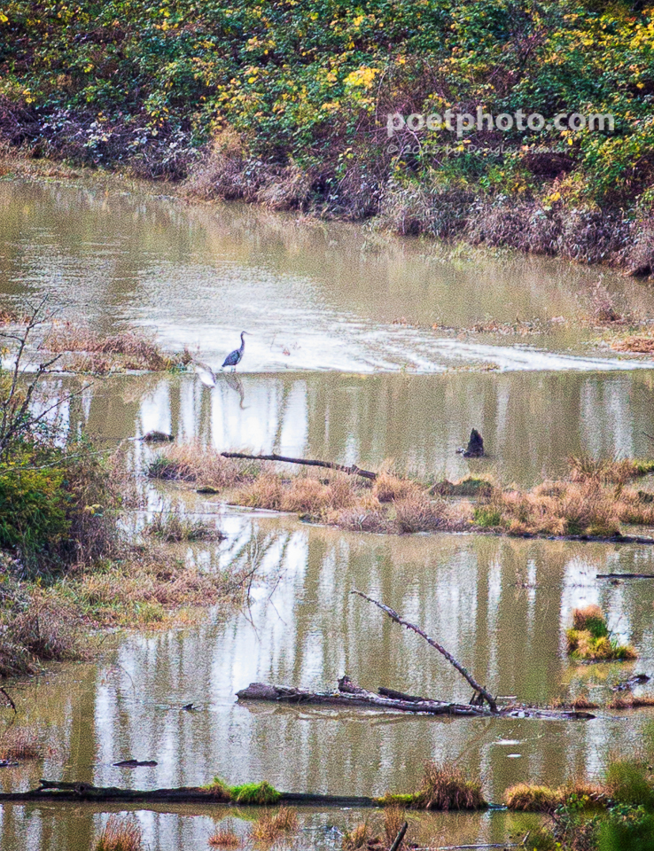
East Monroe During Nov 18, 2015 flood
With the blackberry bush ruse now untenable and clearly too little compensatory flood storage available to allow for raising the building site a foot above floodplain, the only option was to lower the floodplain. So, the engineering firm brings in an additional unimpeachable expert to impeach their own unimpeachable conclusions in the 2013 EIS. Miraculously, and to everyone’s astonishment, they “discover”—actually, they decide from a cursory investigation—that there is no culvert beneath the railroad tracks at the entrance end of the slough, so all the water in the slough is coming from ditches along the highway. Now, you might think that would be easy to disprove because every aerial photo shows the slough approaching the tracks from the south and continuing on to the north toward the East Monroe property, but the culvert is deeply submerged and in a difficult place to access. The railroad, BNSF will not confirm or deny there is a culvert there. A local farmer did investigate with an 8′ rod and found what he figured was likely the culvert. But, they’ve got the “expert” who authored the FEMA studies of the Skykomish and Snoqualmie rivers responding, “Frankly, if there is a culvert there, and it is buried, it is performing the same function as no culvert at all.”
This finding is incredibly convenient. It allows them—using the Army Corp of Engineers’ river analysis software—to model the slough as a very small tributary instead of a side channel of the river. It means flood water can only back onto the property from the west end. This in turn means, at the peak of a flood, the water in the slough is at a complete standstill. And, according to the expert, it means the base flood elevation can be lowered from 67ft to 65.35 ft. And, it means these are now the “existing condition” by which all other impacts are measured.
Well, of course, this is all BS, but it took downloading that software and its 800 page manual, and months of research to undermine the credibility of this expert with his own earlier pronouncements and studies—as well as those of many other experts in the field. Then, the day after the City adopted the new rezone ordinances, we had a flood. The water flowed in from the east end and continued down hill as it always does.
It is in the hands of the Board, now. The City has 10 days to respond to our objections.
Fortunately for the cause, another neighbor has a much better grasp of the legal inadequacies of this rezone attempt, and she submitted her own 30 pages on the subject. They have a lot to weasel their way out of. I’m pretty confident they will not succeed.